Hemis to Tso Moriri
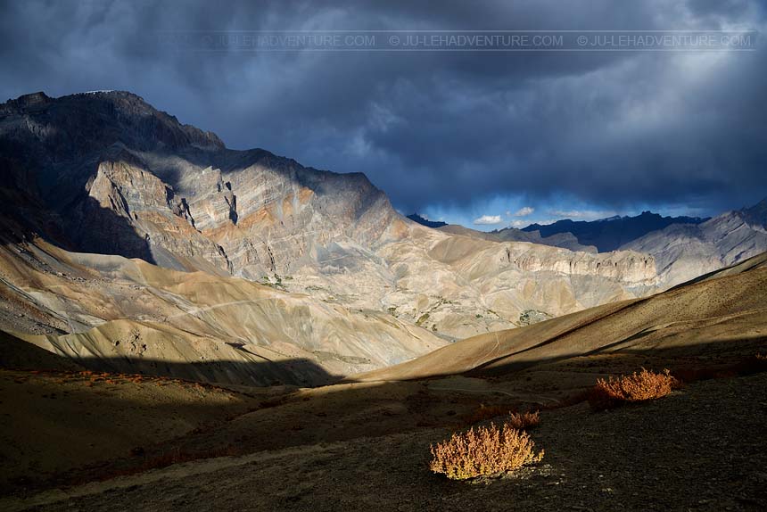
Zanskar trek from Lamayuru to Darcha
Duration: 19 days
Difficulty: level 5
Distance: 291 km
Max elevation: 5062m
Elevation gain / loss: +8535m / -8555m
This challenging trek from Lamayuru to Darcha follows a 19-day itinerary across Zanskar. You will walk through beautiful landscapes, visit ancient monasteries and stay in charming remote villages. Homestays provide a fascinating window into the local culture: you will cook and eat with the family, you might even be able to help planting or harvesting the fields.


Itinerary
Day 1: Lamayuru - Prinkti La - Wanla
Time: 3-4 hrs
Distance: 9.1 km
Elevation gain / loss: +369m / -592m
| - | visit the well-known monastery of Lamayuru just above the village |
| - | cross the Prinkti La pass and walk through the small village of Shilla before reaching Wanla |
| - | homestay can be arranged in Wanla |

Day 2: Wanla - Hanupatta
Time: 6-7 hrs
Distance: 17.5 km
Elevation gain / loss: +569m / -0m
| - | walk along the river and pass through barley fields studded with whitewashed farmhouses |
| - | the trail goes through a narrow gorge via Phenjila before reaching Hanupatta |
| - | homestay possibility in Hanupatta |

Day 3: Hanupatta - Sir Sir La - Photoksar
Time: 7-8 hrs
Distance: 16.6 km
Elevation gain / loss: +1117m / -690m
| - | cross the river and start ascending the Sir Sir La, the pass offers a nice view of the Zanskar range |
| - | walk down to the village of Photoksar |
| - | homestay possibility in Photoksar |

Day 4: Photoksar - Singge La Base Camp
Time: 4-5 hrs
Distance: 11.5 km
Elevation gain / loss: +332m / -182m
| - | cross the Bumiktse La and enter the wide valley of Photang where villagers keep their yaks and horses for grazing |
| - | go to the base camp |

Day 5: Singge La Base Camp - Singge La - Lingshed
Time: 8-9 hrs
Distance: 20.5 km
Elevation gain / loss: +1073m / -1483m
| - | cross the Singge La and enjoy the great view from the pass |
| - | cross the 2 small passes (Kyukpa La and Margum La) before reaching Lingshed village |
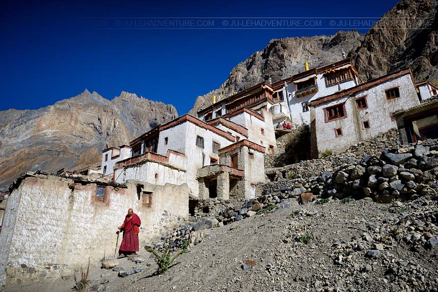
| - | visit the beautiful monastery of Lingshed where more than 60 monks live |
| - | homestay possibility in Lingshed |

Day 6: Lingshed - Hanuma La - Snertse
Time: 7-8 hrs
Distance: 17.8 km
Elevation gain / loss: +1119m / -1253m
| - | pass through the village of Lingshed and follow the trail to Hanuma La base |
| - | go up gradullay towards the Hanuma La, enjoy the panoramic view of the Zanskar mountains and Lingshed village from the pass |
| - | walk down along a stream that leads to Snertse |

Day 7: Snertse - Purfi La - Hanamur
Time: 4-5 hrs
Distance: 12.4 km
Elevation gain / loss: +610m / -938m
| - | cross the Purfi La pass and follow the Zanskar river until the village of Hanamur |
| - | Himalayan brown bears and blue sheep can sometimes be spotted in this area |

Day 8: Hanamur - Pishu
Time: 4-5 hrs
Distance: 15.4 km
Elevation gain / loss: +141m / -150m
| - | easy walk along the Zanskar river |
| - | pass through the village of Pidmo which has few households and continue to Pishu |
| - | homestay possibility in Pishu |

Day 9: Pishu - Karsha
Time: 5-6 hrs
Distance: 16.9 km
Elevation gain / loss: +251m / -0m
| - | easy walk to Karsha |
| - | visit the monastery of Karsha, the largest and the most important monastery in Zanskar. It is built on a mountainside above the village |
| - | homestay possibility in Karsha |

Day 10: Karsha - Padum
Time: 3 hrs
Distance: 11.2 km
Elevation gain / loss: +77m / -174m
| - | walk towards Padum, the capital of Zanskar |
| - | it is also possible to drive from Karsha to Padum |
| - | homestay possibility in Padum |

Day 11: Padum - Raru
Time: 7-8 hrs
Distance: 22.6 km
Elevation gain / loss: +389m / -164m
| - | follow a long but easy trail leading to Raru |
| - | on the way, you can visit the monastery of Bardan which is perched on a hill |
| - | possibility to drive from Padum to Raru |
| - | homestay possibility in Raru |

Day 12: Raru - Changpa Tsetan
Time: 5-6 hrs
Distance: 16.0 km
Elevation gain / loss: +379m / -355m
| - | the trail follows the Tsarap river down through a craggy landscape |
| - | you need to cross the stream several times before arriving to Changpa Tsetan |

Day 13: Changpa Tsetan - Purne
Time: 3 hrs
Distance: 9.7 km
Elevation gain / loss: +225m / -207m
| - | the trail continues to follow the Tsarap river |
| - | walk past the villages of Surle, Kalbok and Zantang to the confluence of Tsarap and Kargyak river and a little ahead is the village of Purne |

Day 14: Purne - Phuktal - Purne
Time: 4 hrs
Distance: 11.7 km
Elevation gain / loss: +233m / -233m
| - | walk towards the monastery of Phuktal from Purne |
| - | Phuktal gompa is spectacularly located at the mouth of a huge cave high up in the vertical mountainside |
| - | meet the resident monks at the monastery and take time visiting around |

Day 15: Purne - Tabley
Time: 5-6 hrs
Distance: 16.9 km
Elevation gain / loss: +485m / -281m
| - | walk along the Kargyak river |
| - | you will see the villages of Testha, Kuru and Tanse before reaching Tabley |

Day 16: Tabley - Lakung
Time: 7-8 hrs
Distance: 22.0 km
Elevation gain / loss: +455m / -0m
| - | walk through Kargyak village and follow the wide valley leading to the grazing land of Lakung |

Day 17: Lakung - Shingo La - Ramjak
Time: 6-7 hrs
Distance: 16.4 km
Elevation gain / loss: +571m / -678m
| - | follow the trail to Shingo La base |
| - | cross the Shingo La, the highest pass of the trek |
| - | descend to Chumik Nagpo and further down is the village of Ramjak |

Day 18: Ramjak - Pallamo
Time: 4-5 hrs
Distance: 15.3 km
Elevation gain / loss: +55m / -833m
| - | a gradual descent leads to Pallamo |

Day 19: Pallamo - Darcha
Time: 3-4 hrs
Distance: 11.7 km
Elevation gain / loss: +57m / -342m
| - | the trail to Darcha is fairly easy and you can visit the gompas of Rarik and Chika on the way |

Getting to / from the trek
| - | it takes 3 hours to drive from Leh to Lamayuru (115 km) |
| - | Darcha is 150 km from Manali and 315 km from Leh |
It is worth taking some extra time to stop and visit the highlights in the area, check the Indus valley tour to Lamayuru for more details.
All the itineraries can be customized to suit your own special interests, preferences and abilities. Please contact us for more information.