Hemis to Tso Moriri
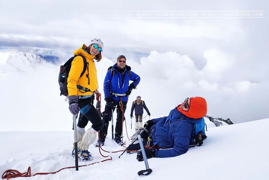
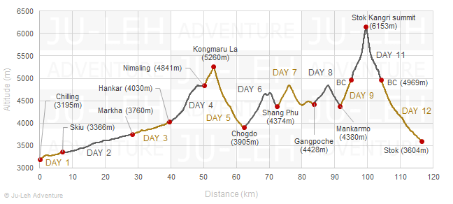
Markha valley trek & Stok Kangri climb (6153m)
Duration: 12 days
Difficulty: level 5
Distance: 117 km
Max elevation: 6153m
Elevation gain / loss: +5753m / -5343m
Stok Kangri has been closed since 2020. This measure has been taken in order to protect the glacier which is the main source of water for Stok village. As of now, there is no confirmation whether the peak will reopen in 2026.
The Markha valley trek is a very famous trek and all the villages in the valley offer homestay which is a nice opportunity for travelers to catch a glimpse of the daily lives of the villagers. The Markha valley is part of the Hemis National Park, home to snow leopard and other wild animals.
Stok Kangri is a relatively “easy” 6000m+ peak, perfect for a first mountaineering experience in the Himalayas. The climb does not require special mountaineering skills; the major challenge comes from the very high altitude.
If you would like to join a group, check our Fixed Departure Treks.
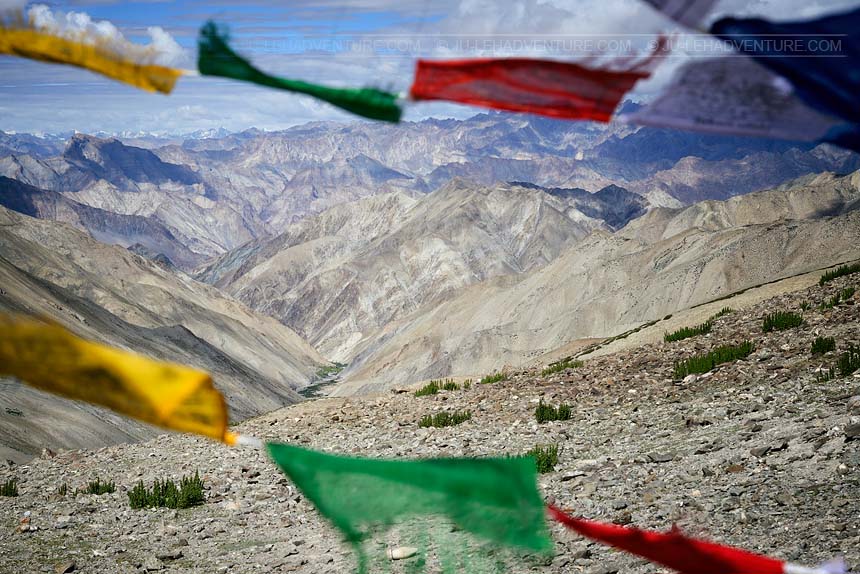
Itinerary
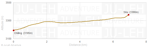
Day 1: Chilling - Skiu
Time: 2-3 hrs
Distance: 6.9 km
Elevation gain / loss: +189m / -18m
| - | after crossing the Zanskar river, the trail leads to the beautiful Markha valley |
| - | homestay is available in Skiu |
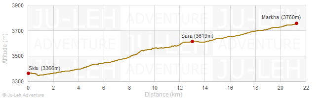
Day 2: Skiu - Markha
Time: 6-7 hrs
Distance: 21.2 km
Elevation gain / loss: +451m / -57m
| - | the trek from Skiu to Markha follows the river and passes through small villages |
| - | the village of Markha consists of around 20 households, it is the biggest village in the valley |
| - | spend some time visiting the ancient gompa and the ruined fort above the village |
| - | homestay can be arranged in Markha |
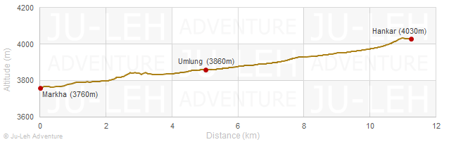
Day 3: Markha - Hankar
Time: 4-5 hrs
Distance: 11.2 km
Elevation gain / loss: +305m / -35m
| - | the trail follows the river |
| - | visit the small but impressive cliff-side monastery of Techa located a few kilometers before Umlung village |
| - | if you want to experience village life, you can stay in homestay in Hankar |
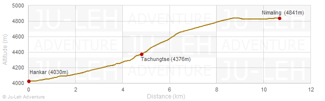
Day 4: Hankar - Nimaling
Time: 5-6 hrs
Distance: 10.7 km
Elevation gain / loss: +836m / -25m
| - | continue your trek to the plateau of Nimaling which is the summer pasture for the livestock of Markha valley |
| - | from Nimaling, you can hike to the base of Kang Yatse glacier in a few hours |
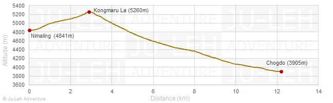
Day 5: Nimaling - Kongmaru La - Chogdo
Time: 5-6 hrs
Distance: 12.2 km
Elevation gain / loss: +425m / -1362m
| - | cross the Kongmaru La which offers excellent views of Kang Yatse and Karakoram peaks |
| - | from the pass, it’s a steep and long descent towards the Shang gorge. There are several river crossings before reaching the village |
| - | homestay possibility in Chogdo |
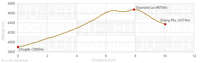
Day 6: Chogdo - Gyuncho La - Shang Phu
Time: 5-6 hrs
Distance: 10.0 km
Elevation gain / loss: +793m / -324m
| - | the trail heads toward west into a tributary valley |
| - | gradual climb to the Gyuncho La before reaching Shang Phu |
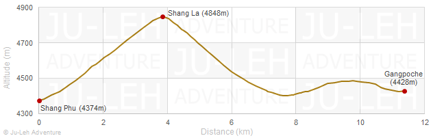
Day 7: Shang Phu - Shang La - Gangpoche
Time: 5-6 hrs
Distance: 11.4 km
Elevation gain / loss: +563m / -509m
| - | cross the Shang La, descend to the Tokpo river and follow it until Gangpoche |
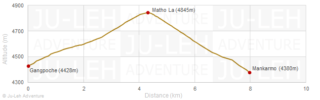
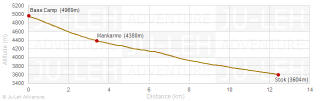
Day 8: Gangpoche - Matho La - Mankarmo
Time: 4 hrs
Distance: 8.0 km
Elevation gain / loss: +416m / -464m
| - | cross the Matho La from where you will have a nice view of Stok Kangri |
| - | descend into the valley and walk to the shepherd settlement at Mankarmo |
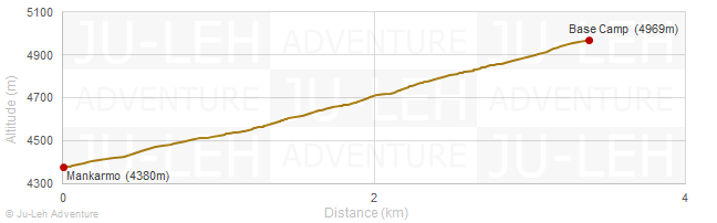
Day 9: Mankarmo - Base Camp
Time: 2-3 hrs
Distance: 3.4 km
Elevation gain / loss: +589m / -0m
| - | from Mankarmo the trail ascends the valley and you will have a clear view of Stok Kangri |
| - | you may need to cross the river a couple of times before reaching the base camp |
Day 10: Rest day and time for final preparations
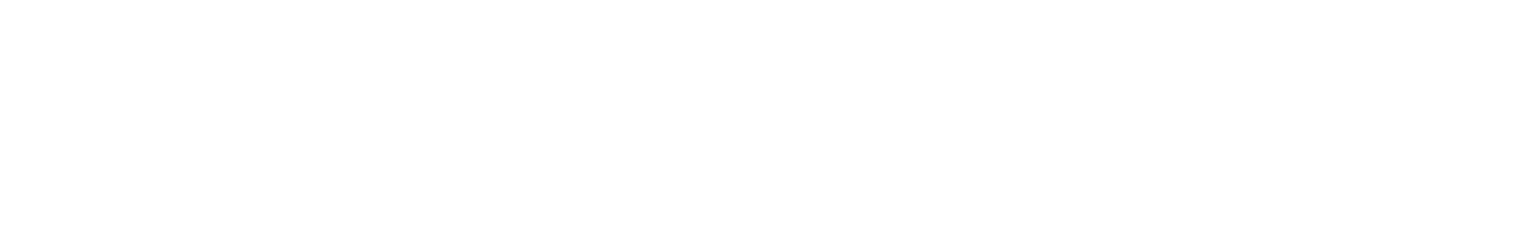
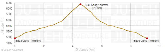
Day 11: Base Camp - Stok Kangri Summit - Base Camp
Time: 8-11 hrs
Distance: 9.1 km
Elevation gain / loss: +1184m / -1184m
| - | the climb to the summit starts very early before dawn. It takes a few hours to reach the glacier. Keep going up on the steep path until you reach the ridge leading to the summit. The view from the summit is spectacular; you can see the snow-topped peaks of the Himalayas, Karakoram and Zanskar ranges. On a clear day, you can also see K2 in the distance |
Day 12: Base Camp - Stok
Time: 3-4 hrs
Distance: 12.4 km
Elevation gain / loss: +0m / -1366m
| - | walk through the valley of multi-coloured rocks before reaching Stok village |
Getting to / from the trek
| - | it takes one hour and a half to drive from Leh to Chilling (60 km) |
| - | it takes 30 minutes to drive from Stok to Leh (20 km) |
All the itineraries can be customized to suit your own special interests, preferences and abilities. Please contact us for more information.