Hemis to Tso Moriri
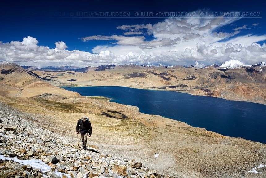
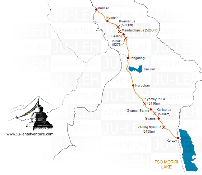
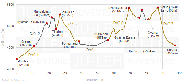
Rumtse to Tso Moriri trek (Rupshu)
Duration: 7 days
Difficulty: level 4
Distance: 98 km
Max elevation: 5435m
Elevation gain / loss: +3002m / -2690m
The trek from Rumtse to Tso Moriri is one of the most beautiful treks in Ladakh. It takes you through the Changthang region, a high-altitude plateau that has unique landscapes and stunning lakes like Tso Kar and Tso Moriri. This region is home to the Changpa nomads with their pashmina goats and yaks. It’s an exceptional trek, but demanding because of the crossing of numerous high passes above 5000m.
If you would like to join a group, check our Fixed Departure Treks.
Itinerary
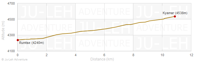
Day 1: Rumtse - Kyamar
Time: 4 hrs
Distance: 10.9 km
Elevation gain / loss: +298m / -0m
| - | follow the trail to Kyamar which was once known as the salt road. Through this valley, the salt from Tso Kar was transported to Leh and the Indus valley |
| - | the sceneries and landscapes are different from the rest of Ladakh |
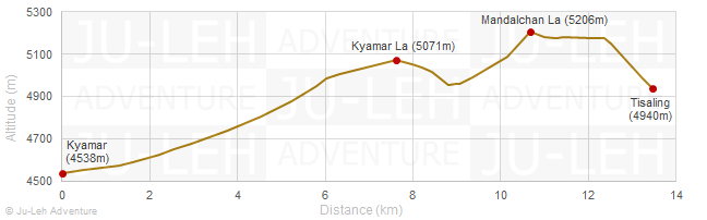
Day 2: Kyamar - Kyamar La - Mandalchan La - Tisaling
Time: 6-7 hrs
Distance: 13.5 km
Elevation gain / loss: +786m / -384m
| - | move upwards gradually towards the Kyamar La and enjoy the fantastic view of the Changthang region from the pass |
| - | climb down towards Tiri Doksa, a temporary shelter for the shepherds |
| - | keep to the trail and climb the Mandalchan La and then climb down to Tisaling |
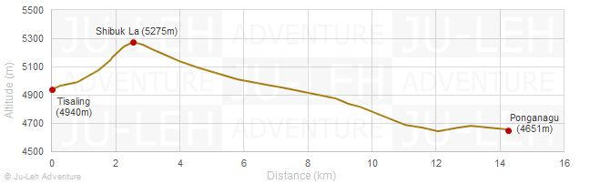
Day 3: Tisaling - Shibuk La - Ponganagu
Time: 6 hrs
Distance: 14.3 km
Elevation gain / loss: +377m / -666m
| - | follow the trail as it slowly begins to gain elevation towards the Shibuk La |
| - | enjoy the spectacular view of Tso Kar lake from the pass |
| - | walk down to Ponganagu near Tso Kar lake |
| - | this area is well known to observe wildlife such as migratory birds, kiang (wild asses), marmots and ibex |
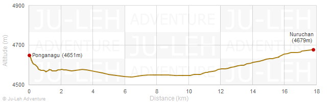
Day 4: Ponganagu - Nuruchan
Time: 5-6 hrs
Distance: 17.8 km
Elevation gain / loss: +173m / -145m
| - | continue your trek walking along the west side of Tso Kar lake where you might be able to spot black necked cranes and brahmini ducks. Tso Kar is also called "white lake" because of the salt that get deposited on its banks |
| - | walk to Nuruchan |
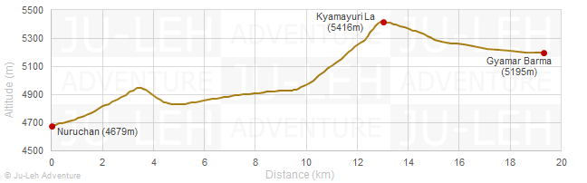
Day 5: Nuruchan - Kyamayuri La - Gyamar Barma
Time: 7-8 hrs
Distance: 19.3 km
Elevation gain / loss: +855m / -339m
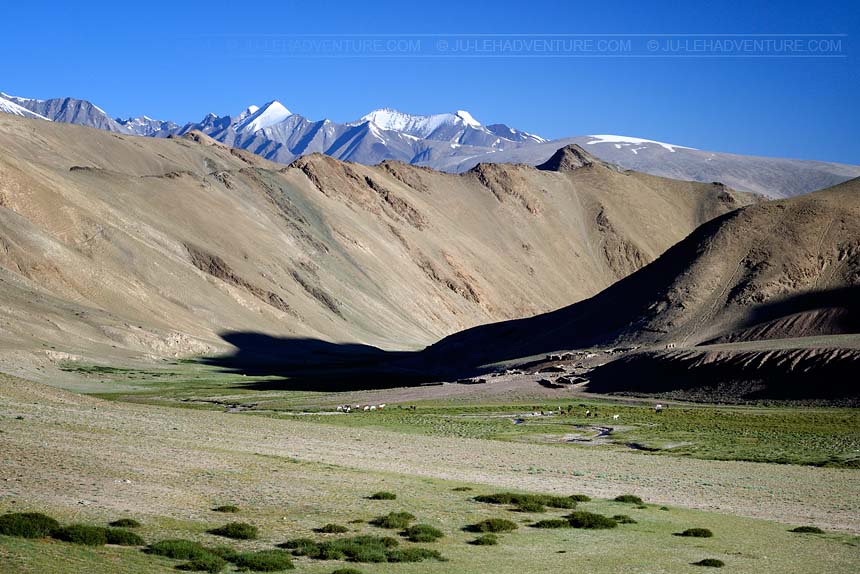
| - | you will be crossing two passes today (Horlam Kongka La and Kyamayuri La) to reach Gyamar Barma |
| - | on the way, you will meet several nomad families with their yaks, sheep and goats |
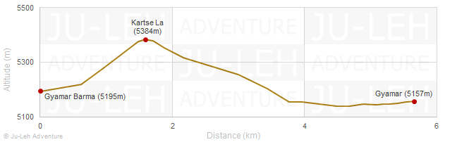
Day 6: Gyamar Barma - Kartse La - Gyamar
Time: 3 hrs
Distance: 5.7 km
Elevation gain / loss: +213m / -251m
| - | after crossing the Kartse La, go down towards the Gyamar valley at the foot of Yalung Nong |
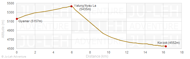
Day 7: Gyamar - Yalung Nyau La - Korzok
Time: 5-6 hrs
Distance: 16.3 km
Elevation gain / loss: +300m / -905m
| - | cross the Yalung Nyau La, the highest pass of the trek and have a great view of Tso Moriri lake from the top |
| - | walk down to Korzok village, on the bank of Tso Moriri |
Getting to / from the trek
| - | it takes 2 hours to drive from Leh to Rumtse (80 km) |
| - | it takes 7 hours to drive from Korzok to Leh (215 km) |
It is worth taking some extra time to stop and visit the highlights in the area, check the Indus valley tour to Hemis for more details.
All the itineraries can be customized to suit your own special interests, preferences and abilities. Please contact us for more information.